Reaching Trail
Jump to navigation
Jump to search


Location of Warrior Statue
Reaching Trail - L4k7

Versioning
This article could contain outdated information that is inaccurate for the current version (1.57) of the game. It was last updated for 1.56.
| “ | A few miles north of the Moors lies The Reaching Trail, a rural village that built up around a mountainous path between Callum's Cape and the Reaching River. Colonial Paratroopers cut off Warden soldiers fleeing to the north and set up camp, establishing their own northern base of operations. | „ |
| — Old In-game description |
The Reaching Trail was a Skirmish map, described as a tightly paced map with a mix of varied elevations and tactical opportunities inside a small mountain pass. It is highlighted that making use of these different natural obstacles will be vital as you work to cut off supply lines and prepare for coordinated assaults.
Update History
- 0.11 - Reaching Trail was added into the game as a Skirmish map.
- 0.14 Amphibious Assault - The map was expanded upon.
- 0.20 Foundation of War - Safehouses were introduced to the game and placed on the map.
- 0.26 War Machine - Map was been updated to its hexagonal design and is implemented as part of the World Conquest.
- 1.50 Inferno - Preplaced Railway Tracks and Train Bridges were introduced to the game, with a permanent Railway Track placed on the map.
- NOTE: These tracks were quietly removed in a later update.
- 1.52 - Introduced minor changes to the map.
- A collapsed pillar in Brodytown was rotated to not obstruct logistical structures.
- Rocket Launch Sites were disabled. Their map icon will not appear, nor can they be rebuilt.
- 1.54 Naval Warfare - Introduced multiple changes to the map.
- Rocket Launch Sites have been removed from the map.
- Brodytown (as a logistics areas) have been reworked to spread out traffic.
- Observation Towers in non-coastal/island regions were removed.
Lore
Meat Facility
Meat Facility
You’ve stumbled upon what appears to be some form of meat processing facility.
Inside the cylinders, you see the remains of—as far as you can tell—small birds, oils, and a wide variety of salts and spices.
Curious Poetry
Curious Poetry
There’s some intriguing poetry on a journal page marked by a folded corner.
Eagles fly, but only beasts takes the sun;
The sands of time have turned to flies.
It's no gift, but a garish curse, the machine always seems to run.
Who tells tall tales? it is not I, my brethren are plump with lies.
Why shoot the messenger?
But I know you will, Callahan always takes my gun.
The sands of time have turned to flies.
It's no gift, but a garish curse, the machine always seems to run.
Who tells tall tales? it is not I, my brethren are plump with lies.
Why shoot the messenger?
But I know you will, Callahan always takes my gun.
Shocking Massacre
Shocking Massacre
There is chaos all around you.
Blood still stains the frozen earth and viscera is splattered about.
The blood has long since dried, the corpses frozen for many moons, yet curiously, the coals in the fire still smoulder.
Almost as if someone had spent time here recently.
The blood has long since dried, the corpses frozen for many moons, yet curiously, the coals in the fire still smoulder.
Almost as if someone had spent time here recently.
Cara's Rifle
Cara's Rifle
A standard-issue Loughcaster rifle.
The name, "Cara"is carved into the trigger guard.
Small cuts are marked into the stock. This rifle cannot be cleaned. This rifle cannot be loaded. This rifle will not fire. It's too light. Blood pours out from the barrel when the trigger is squeezed.
You feel it must be cursed and aren't sure why you still carry it.
Small cuts are marked into the stock. This rifle cannot be cleaned. This rifle cannot be loaded. This rifle will not fire. It's too light. Blood pours out from the barrel when the trigger is squeezed.
You feel it must be cursed and aren't sure why you still carry it.
Warrior Statue
Warrior Statue
An imposing sculpture of a massive antlered warrior.
A terrifying vision from afar, this massive stone statue must have taken an army to carve. Before it falls on you, you think it’d be best to find greener pastures.
Reaching Trail - L4k7
Warrior Statue
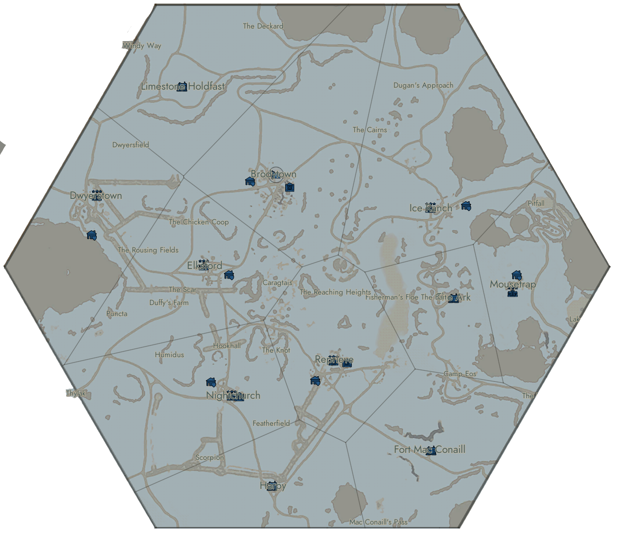
Map
Map Locations
- The Ark
- The Bait
- Brodytown
- The Cairns
- Camp Eos
- Caragtais
- The Chicken Coop
- The Deckard
- Duffy's Farm
- Dugan's Approach
- Dwyersfield
- Dwyerstown
- Elksford
- Featherfield
- Fisherman's Floe
- Fort Mac Conaill
- Harpy
- Hookhall
- Humidus
- Ice Ranch
- The Knot
- Limestone Holdfast
- Mac Conaill's Pass
- Mousetrap
- Nightchurch
- Pitfall
- Puncta
- The Reaching Heights
- Reprieve
- The Rousing Fields
- The Scar
- Scorpion
- Thýlak
- Windy Way
| Click on a region to open the corresponding page. |
|---|
 |