Community Guides/Map Guide
This article could contain outdated information that is inaccurate for the current version (1.56) of the game. It was last updated for 1.53.
This guide teaches you how to understand and use the map and all its functionalities.
Overview
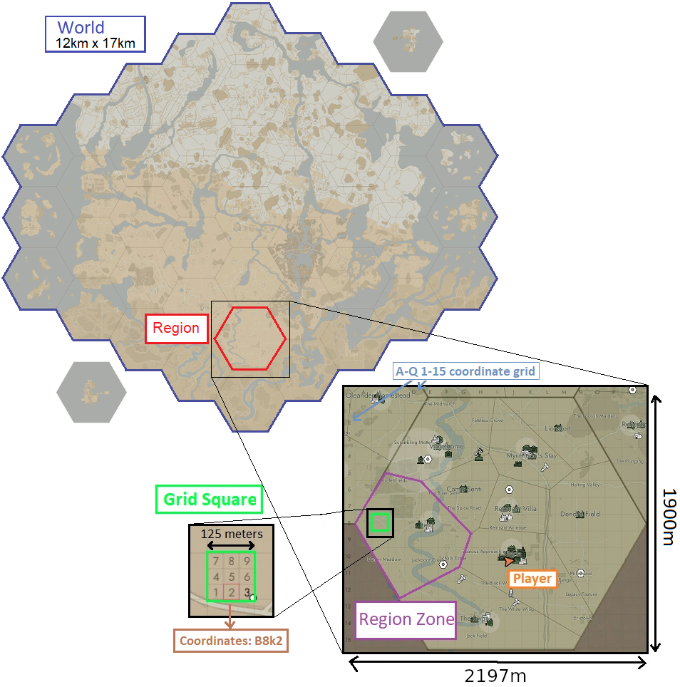
The World Map is divided in 37 hexagonal Regions of side length 1097m, which are themselves divided in Region Zones. The region you're in will also have a grid superimposed on it, using letters A-Q for horizontal coordinate and numbers 1-15 for vertical. Each large square on that Grid is 125m by 125m, and each is subdivided into 9 small squares. With this you can transmit very accurate location info, simply say "G9k3" (k for keypad) for example. If particular regions appear darkened on the map it means they are not included for the current war or the region server is offline/restarting.
The orange arrow ![]() on the map is your character.
on the map is your character.
In the top left corner of your map, you'll see the state of the war and the War Achievements.
Center left is the Map Legend and Filters.
Bottom Left section is info related to your location, the world date, time, and map intel.
Controls
LMB+drag: Move the map aroundScroll Wheel: Zoom in/outspacebar: Centers the map on your current position.RMB: Place/remove your map post.Ctrl+LMB: Copy map coordinates into chatTab: cycle through Public and Reserve Storages when your mouse is on a Storage Depot or Seaport.
Move your mouse over certain icons to show additional info. Storage Depots and Seaports will show the content of all stockpiles you have access to (press Tab to cycle through stockpiles). Resource Fields will show how many nodes are left and Resource Mines will show their content but only if your faction controls the region zone they're in. Your bases will show their content and the progress on their base upgrades. Factories and Mass Production Factories will show the number and type of orders queued. Refineries will show the content of their stockpile but NOT your own queues.
Map Legend
Hover your mouse over each icon to see what they represent.
Blue and Green icons always represent Warden and Colonial factions. White icons are neutral or destroyed structures.
The map intelligence icons represent:
 Infantry: Each dot is one soldier.
 Vehicle: All vehicles appear on the map as triangles, even the bicycle.
 Structure: This diamond icon is only for Watch Towers and Observation Bunkers.
 Defense: A pentagon icon only used for active defenses, such as Pillboxes, Bunker Garrisons, or Emplacements.
 Howitzer: See Light Artillery and Heavy Artillery
 Field Hospital: Each cross is a Field Hospital.
 Outpost: Enemy Encampment, Bunker Base, or Border Base. Friendly or destroyed bases use unique icons.
 Facilities: Reserved for production Facilities.
 Large Ships: Each rectangle is a Large Ship.
The structures with their own unique icon are always visible on the map for both factions and their status (destroyed, faction ownership, Tier) is always updated even if you do not update your map intelligence. There are a few exceptions:
- Encampments, Bunker Bases are only visible if destroyed or owned by your faction
- Transfer Stations, Assembly Stations, and Field Modification Centers are only visible if owned by your faction
- Border Bases are only visible if owned by your faction or are unclaimed.
Filters
You can filter the information on the map by toggling each category in the legend:
- BASES: all types of bases
- RESOURCES: Resource Fields and Resource Mines.
- STRUCTURES: the large buildings with unique icons, except the Bases and Resource Mines.
- LOCATIONS: the names of map locations
- MAP POSTS: map posts
- REGION ZONES: Region Zones
- RAILWAY TRACKS: The Railway Tracks placed by your faction and the Preplaced Railway Tracks
- INTELLIGENCE: Map Intelligence
You can also toggle individual icons in the legend by clicking them. You can toggle all icons except one by using Shift+LMB on an icon.
Map Terrain
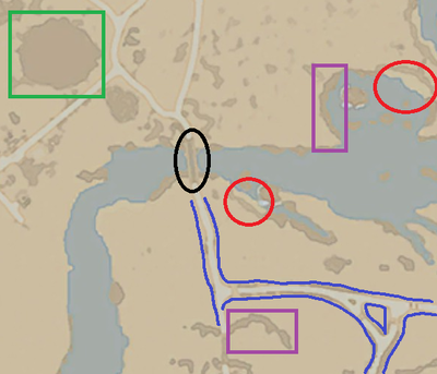
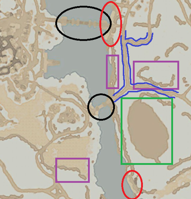
Bridges: (Circled in black)
Roads: (Shown in dark blue)
Roads are white on southern maps and light brown on snow northern maps.
Beach: (Circled in red)
Beaches are light yellow on the map, with a light brown outer border on snowy maps. Beaches are the only place beside Shipyards and Seaport docks where a barge or Landing Ship can land, and the only spots where you can build motorboats. It's thus very important to be able to recognize them on the map.
Mountains: (In green square)
Mountains are large impassable obstacles, in brown on the map. Don't confuse them with cliffs.
Cliffs and elevation: (In purple square)
Cliffs are the only indicators of elevation on the map. Since holding the high ground is a tactical advantage, knowing the topography of terrain is important. Cliff and climbable rocks are usually visible on the map. The map doesn't show actual elevation but it can inferred from looking at the cliffs.
Rivers & Lakes:
Rivers and lakes are obviously in light blue on the map. During Snow Storms rivers can freeze and become crossable by infantry and vehicles.
Map Intelligence
Map Posts
Region Zones
Each Region Zone contains a single Town Base or Relic Base. Ownership of that base determines the ownership of the zone and its blue or green color on the map. When you hover your mouse over any zone, text will state whether this territory started as "Friendly territory" or as "Neutral / Enemy territory". This is determined at the start of a war and influences how fast a base in that zone will unlock its upgrades. Ownership of a given zone allows you to check the content of resource fields in it by putting your cursor on it.
Region Border Mechanics
Region borders have special mechanics. You cannot build within 60m from any region border, unless you're in the 40m radius of a Border Base. Structures built between 60m and 150m from a region border suffer from unpreventable fast Decay.
When one faction owns the entirety of one region and the other faction owns the entire neighboring region, the border between those two regions becomes a frontier border. It's shown on the map by a thick red line. This activates the use of Border Bases. Intel gathering structures stop working if they are within 220 meters of a frontier border, but only on the side their faction controls. The border stops being a frontier border once a faction captures a Town Base or Relic Base in the enemy's region.
Tips
- Destroyed enemy bases of any type will show up on your map for a while, even if not in intel range.
- LUV and radio backpack infantry don't show any white intel radius circle on the map
- When doing call outs include the region and closest town name, or copy/paste coordinates (with
Ctrl+LMB) and add closest town.


